| Airport Diagram |
|---|
| Navigate to 68C |
| 68C-Road Map |
| Friday Lunch |
| Images of Iola |
| People of 68C |
| Feedback Form |
| 68C Home |
| W X |
Iola Weather | METAR Map | Windy.com | Natl. Radar | TFR Map |
|---|---|---|---|---|---|
|
The NWS Aviation Weather Center website is the only FAA approved Internet source of aviation weather for pilot briefings.
Get TAFs for KCWA, KATW, KGRB, KMSN, KMKE. |
|||||
| Pop-up Utilities >>> | 68C Time | Perpetual Calendar | Browser Profiler | To-Do List | TicTacToe with Rudder |
|---|
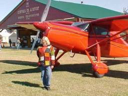
Central County - 68CGrass roots flying at its best! Located in beautiful central Wisconsin (Waupaca County), Iola airport is a haven for recreational flying and sport aviation fellowship. Visit 68C airport for breakfast the weekend of the Iola Old Car Show in July, or for the weekly Iola Friday lunches for members of the Central County Flyers Association.
|
 |
|
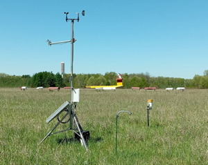
Check out 68C's WISCONET weather / soil / solar radiation data station located right here on the field. |
| FAA Identifier: | 68C |
| Airport use: | Open to the public |
| Activation date: | 09/1947 |
| Lat / Long: | 44-30-19.9320N / 089-01-30.3940W 44-30.332200N / 089-01.506567W 44.5055367 / -89.0251094 |
| Elevation: | 876 ft. / 267 m |
| Pattern altitiude: | 1,876 ft. / 572 m |
| Magnetic Variation: | 01W (1985) |
| Attendance: | Unattended |
| Time Zone: | UTC -6 (UTC -5 during Daylight Saving Time) |
| From city: | 4 miles East of Iola, WI |
| FSS: | 800-WX-BRIEF |
| AWOS at KPCZ (10 nm S): | 118.625 (920-867-2407) |
| AWOS at KCLI (14 nm NE): | 120.675 (715-823-7691) |
|
|
This page last updated on July 13, 2026 by Bob: |